The Acharistsqali River: The Lifeline of Adjara
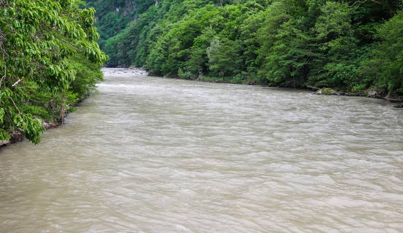
The Acharistsqali River (მდინარე აჭარისწყალი), which translates to “River of Adjara,” is the main river and lifeline of the Autonomous Republic of Adjara in southwestern Georgia. Originating high on the Arsiani Range, it flows for 90 kilometers through the stunning, steep-sided valleys of Upper Adjara before joining the Chorokhi River near Batumi. The river is the central artery of the region, and its valley is a densely populated corridor that is home to a unique culture, ancient traditions, and breathtaking natural beauty. The main road connecting the coastal city of Batumi with the rest of Georgia (via the Goderdzi Pass) follows this valley, making the river a constant companion for travelers.
The Acharistsqali is not just a scenic marvel; it is also a powerhouse of the region’s economy. It is the site of the significant Ajaristsqali HPP Cascade, a series of hydroelectric power plants that harness the river’s energy. Furthermore, its valley is dotted with picturesque villages, terraced vineyards growing rare local grape varieties, and numerous historical monuments, most notably the iconic medieval arched stone bridges, often called “Tamar’s Bridges.” Flowing through a landscape of lush subtropical forests, tea plantations, and alpine meadows, the Acharistsqali is a true symbol of Adjara’s rich natural and cultural heritage.
ℹ️ General Information
- Name of River: Acharistsqali River (მდინარე აჭარისწყალი)
- Location: Adjara Autonomous Republic (Khulo, Shuakhevi, Keda, Khelvachauri municipalities).
- Length: 90 km (56 miles)
- Basin Size: 1,540 km² (590 sq mi)
- Source (Origin): Arsiani Range, near Goderdzi Pass.
- Mouth (Where it flows): Right tributary of the Chorokhi River.
- Main Tributaries: Skhalta, Chirukhistskali.
📍 Geography & Course
The river begins as a mountain stream and grows rapidly, fed by numerous tributaries. It flows westward through a deep, V-shaped gorge, which is the main geographical feature of Upper Adjara. The valley is characterized by steep slopes, often terraced for agriculture. The river’s flow is powerful and fast, especially during the spring snowmelt. The geology of the valley and the power of the river have made it an ideal location for hydroelectric projects.
🌿 Nature & Ecology
The Acharistsqali basin boasts incredible biodiversity due to its vertical climatic zones. The lower valley features Colchic forests with a mix of deciduous and evergreen trees, while the upper reaches are home to coniferous forests and subalpine meadows. The river itself supports various fish species, including trout. The region is part of the Caucasus biodiversity hotspot and is home to several protected areas, such as the Mtirala National Park, which is located in its watershed.
🏛️ History & Culture
The Acharistsqali valley has been a historically important region, connecting coastal and inland Georgia. Its most famous cultural landmarks are the numerous medieval stone arch bridges.
- Dandalo and Furtio Bridges: These are some of the best-preserved and most elegant examples of these single-arch stone bridges, built during the 11th-12th centuries.
- Skhalta Monastery: A beautiful 13th-century church and monastery complex located in the Skhalta river valley, a tributary of the Acharistsqali.
- Traditional Adjarian Villages: The valley is lined with villages featuring unique wooden houses (“Oda” houses) and a strong sense of local tradition.
🚣 Activities & Tourism
- Cultural & Road Trips: Driving the length of the valley from Batumi to the Goderdzi pass is a popular tourist route to see the bridges, waterfalls, and villages.
- Rafting & Kayaking: The river’s fast-flowing sections are becoming increasingly popular for whitewater rafting.
- Wine Tourism: The Keda district in the valley is known for its unique wines, such as Tsolikouri and Chkhaveri, with many family-run wineries open for tastings.
- Hiking: There are numerous trails leading from the main valley into the surrounding mountains.
🛤️ Accessibility
The Acharistsqali valley is highly accessible. The main Batumi-Akhaltsikhe national road runs along the river for most of its length. The road is paved and in good condition, making it accessible for all types of vehicles year-round, though the Goderdzi Pass can be closed in deep winter.

Leave a review