Georgia’s Rainforest Adventure: Mtirala National Park
Welcome to Mtirala National Park, one of Georgia’s most beautiful and one-of-a-kind natural areas! This park is near the Black Sea coast in the Adjara region, not far from the city of Batumi. It is known for being the wettest place in the country. The name “Mtirala” even means “crying” in Georgian because it gets so much rain and mist all year long (up to 4,500 mm a year!). This constant moisture makes the area very lush and green, like a temperate rainforest, which is what the area looked like millions of years ago.
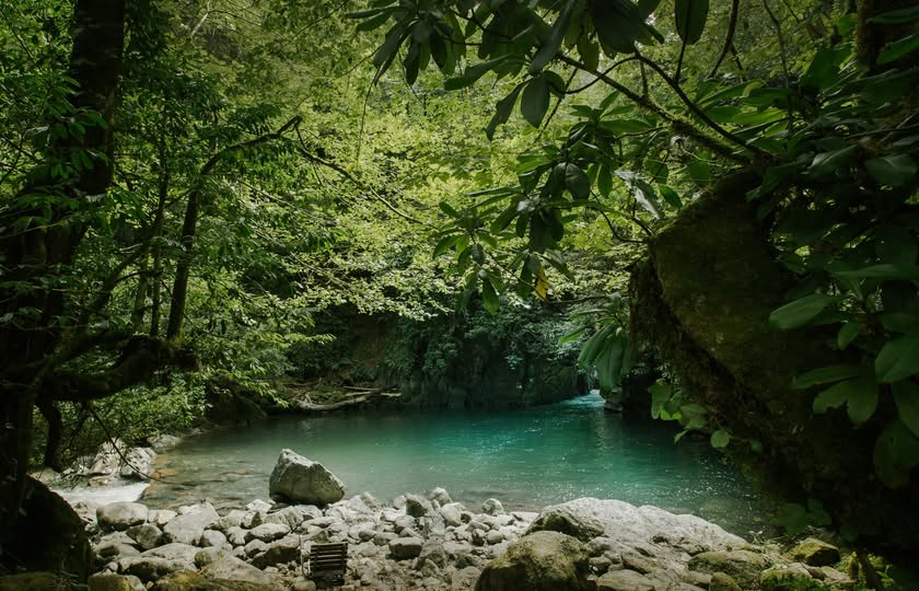
Mtirala National Park was created in 2007 to protect these unique Colchic rainforests, which are known around the world as being very important. “Colchic Rainforests and Wetlands” is a UNESCO World Heritage site that includes Mtirala. This shows how important it is to everyone. It feels like you’re in a fairy tale when you walk through Mtirala. The air is full of moisture, the trees are covered in mosses and climbing ivy, giant ferns grow on the forest floor, and the sound of dripping water is everywhere. There are rivers cutting through steep valleys, beautiful waterfalls falling down rocks, and maybe even a quiet lake that you can’t see.
Plants and animals that do well in wet conditions live in this one-of-a-kind, very humid place. There are old trees like yew and chestnut, evergreen shrubs like rhododendrons and cherry laurel, and beautiful wildflowers. You can also see cool animals like the Caucasian Salamander, different types of frogs, and birds that have adapted to living in the woods. The deeper parts of the forest are home to bigger animals like bears, roe deer, and wild boar.
Even though it has a reputation for being wild and rainy, Mtirala National Park is ready for ecotourists. Chakvistavi is the main starting point, and the village has a helpful visitor center. You can then follow the marked trails from there. The Tsablnari Trail is the most popular. It’s a nice loop walk (or horseback ride) that goes through the chestnut forest to a pretty waterfall and a small lake. The park has even more fun things to do, like zip-lining through the forest canopy and guided canyoning tours (usually in the summer).
You should be ready for rain at any time of year when you visit Mtirala, but walking through this beautiful, misty, ancient rainforest is an experience you’ll never forget. It’s a great place to get in touch with nature at its most vibrant and lush.
Basic ID
Official Name:
Mtirala National Park (მტირალას ეროვნული პარკი).
Type of Protected Area:
This is a National Park (IUCN Category II). It protects the Colchic rainforest ecosystem while also allowing for ecotourism, education, and research that fits in with it.
Established:
2007.
Managing Body:
The Agency of Protected Areas (APA) of Georgia is in charge.
Where it is and how to get there
Location:
Georgia, the Autonomous Republic of Adjara. Includes parts of the municipalities of Kobuleti, Khelvachauri, and Keda. It is on the western slopes of the Adjara-Imereti range, close to the Black Sea coast.
Coordinates/Map:
About 41°40′ N and 41°55′ E. You can get maps at the visitor center and on the APA website.
Closest Towns:
Chakvi is the closest town on the coast and is where you turn off. About 25 km away is Batumi, a big city. Chakvistavi village is where the park’s visitor center and main entrance are. You can get there by taking a road that goes inland from Chakvi.
How to Get There:
By Car/Taxi: From Batumi or Kobuleti, drive to Chakvi and then follow the signs inland toward Chakvistavi (about 15 km from Chakvi). Be careful when driving to Chakvistavi because the road can be narrow, winding, and not always paved. A vehicle with more ground clearance might be better, but regular cars can usually get by, depending on the weather. Public Transportation: Marshrutkas (minibuses) go back and forth between Batumi/Kobuleti and Chakvi often. There aren’t many public transportation options between Chakvi and Chakvistavi, so you might need to take a taxi or make other arrangements. Batumi International Airport (BUS) is the closest airport.
Size and how it looks
Size:
About 15,698 hectares (156.98 km²).
Topography:
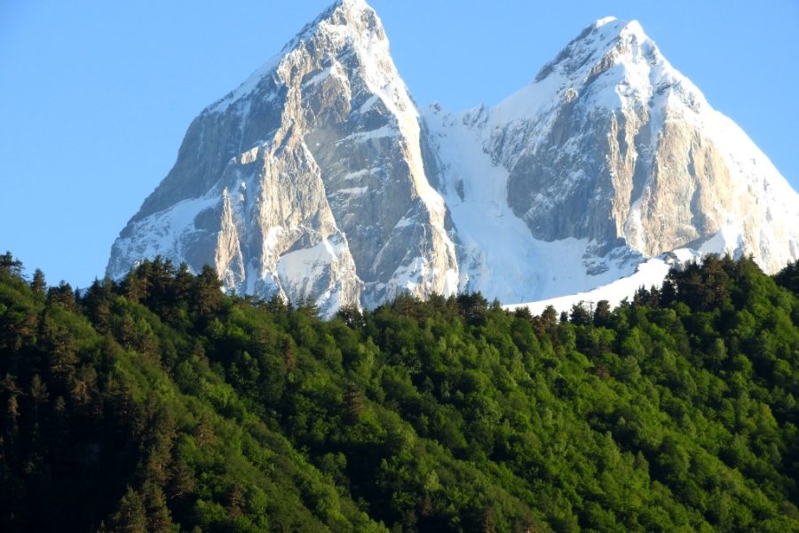
The land is mountainous, with steep slopes, deep river valleys, and gorges. This is a part of the Lesser Caucasus range called Adjara-Imereti. Within the park’s boundaries, the height ranges from about 150 to 250 meters to about 1,500 to 1,600 meters.
Geology and Key Features:
The geology of the mountain range. The area is very humid, has dense Colchic rainforests, the Chakvistskali River valley, many waterfalls, and a lot of mist and fog.
Hydrology:
Because of the very high rainfall, there is a dense network of rivers, streams, and springs. The Chakvistskali is the main river. There are waterfalls, like the Tsablnari waterfall, and a small lake along one of the main trails.
Climate:
Temperate rainforest with a humid subtropical climate. It gets the most rain in Georgia, with up to 4,500 mm falling each year. Winters are mild and very wet. Summers are warm and humid, and it rains a lot. There is a lot of mist and fog all year round.
Importance and Purpose
Reason for Designation:
The Colchic rainforests are relicts from the Tertiary period (millions of years ago), and they need to be protected because they have unique biodiversity and ecosystems. To protect native and rare species that can live in high humidity, and to encourage ecotourism, education, and scientific research that is good for the environment. Also important for keeping watersheds safe.
Important Values:
It shows a unique and old rainforest ecosystem from Colchis. Certain types of habitats are created by very high rainfall and humidity. There are a lot of different plants and animals that are only found in this area. A lot of scientific value for studying how rainforests work. Beautiful scenery. Part of a site that is on the UNESCO World Heritage List.
International Acknowledgment:
- Part of the “Colchic Rainforests and Wetlands” site, which is a UNESCO World Heritage Site (added in 2021).
- Site for the Emerald Network.
- Part of a likely Important Bird Area (IBA) in the area.
Biodiversity (Plants and Animals)
Ecosystems and habitats:
Colchic temperate rainforest (evergreen understory in broadleaf forests). Habitats along rivers. At the highest points, there may be small patches of subalpine meadows.
Important Plant Species:
The most common trees are Oriental Beech, Chestnut (Castanea sativa), Lime (Tilia species), and Alder. A very rich evergreen understory has plants like Pontic Rhododendron, Cherry Laurel, Colchic Holly, Colchic Boxwood, Yew, and climbing plants like Colchic Ivy. There are a lot of ferns, mosses, and lichens on trees and rocks.
Important Animal Species:
Mammals: badger, brown bear, wolf, Eurasian lynx, roe deer, wild boar, European otter, Caucasian squirrel, and marten. Many different kinds of bats. Birds: Some important species are the Booted Eagle, the Middle Spotted Woodpecker, the Semi-collared Flycatcher, the Black Woodpecker, the Green Woodpecker, and maybe even Krüper’s Nuthatch. A lot of other birds live in the forest. Amphibians and reptiles: Humidity makes things very diverse. Includes the native Caucasian Salamander, Caucasian Viper, different types of frogs (like the Marsh Frog and Tree Frog), newts, and lizards.
Endangered or Rare Species:
The brown bear, lynx, and otter are all protected as endangered or rare species in the United States. The IUCN says that the Caucasian Salamander is Vulnerable. Yew (Taxus baccata) and Colchic Boxwood (Buxus colchica) are two plant species that are at risk of extinction because of threats outside of the park. The Colchic rainforest habitat is itself rare and valuable.
Information for Visitors
Visitor Center:
Yes, the Visitor Center is in the village of Chakvistavi. It has information about the park, trail maps, registration, booking for lodging and services, guide and horse rentals, and educational displays. For the most up-to-date contact information and hours, visit the APA website.
Hours and Seasons:
You can usually get to the trails all year, but you should always expect wet conditions. It can rain a lot at any time. The visitor center is open during regular business hours (check the APA website). Adventure activities like zip-lining and canyoning usually happen in the summer.
Fees and Permits:
Yes, you usually have to pay an entrance fee to get into the park or use the trails. You have to pay extra for lodging (shelter/camping), renting a horse or guide, zip-lining, and canyoning. Visit the APA website to see the most up-to-date prices. It is a good idea to sign up at the visitor center.
Trails and Routes:
There are two main marked trails that start near the visitor center: The Tsablnari Trail is a loop that is about 7 km long and takes 4 to 6 hours to walk. The level of difficulty is easy to moderate. Includes a walk through the woods, a waterfall, a small lake, and maybe even a river crossing using a traditional cable-car/pulley system (check to see if it’s working). Good for hiking and riding horses. Tsivtskaro Trail is a short (about 1.5 km) nature and educational trail that is easy to walk.
Adventure Routes:
There are marked paths for zip-lining and canyoning, but you need guides and to make special arrangements and pay fees.
Things to do:
hiking, horseback riding, birdwatching, taking pictures of nature, and going on educational tours. Adventure activities include canyoning (with a guide) and zip-lining. Going to the lake and the waterfall. Loving the one-of-a-kind rainforest vibe.
Place to stay:
In the park, there is a tourist shelter (a simple hut with beds and a stove) near the Tsablnari trail that can sleep 8 to 10 people. There are specific places to camp near the shelter and visitor center. It is very important to book through the visitor center. Nearby: Chakvistavi village has a number of guesthouses where you can stay and eat local food. You can often book these through the visitor center. There are more choices in Batumi, Kobuleti, and Chakvi.
Facilities:
Visitor center (with information, a cafe, likely toilets, and exhibits), marked trails, a tourist shelter, campsites, picnic areas, information boards, and zip-line/adventure structures. You can get water from springs and streams, but you should treat it before you drink it.
Advice on Safety:
Important: a good waterproof rain jacket and pants, as well as waterproof hiking boots. There are often muddy and slippery trails. Rain and fog can happen at any time of year. Be careful; river levels can rise quickly. Use bridges and cable cars when they are available. It can help to use insect repellent. Leeches can live on the ground when it’s very wet. Bring water to drink or ways to clean it. Let the visitor center know about your plans to hike. Be careful of animals.
Laws and Rules
Code of Conduct:
Stay on marked paths to protect the soil and plants that are easily damaged. Try Leave No Trace means taking all your trash with you. To be kind to animals, keep noise to a minimum. Be responsible when using facilities.
Prohibitions:
Hunting and fishing are usually not allowed (look up the rules for fishing if there are any). You can’t pick up plants, mushrooms, or animals. You can only start fires in designated fire pits at picnic and camping areas. It is against the law to litter. You probably need special permission to use drones. Follow the rules for safety when doing adventure activities.
Management and Conservation
Managing Body:
The Agency of Protected Areas (APA) is in charge of managing Mtirala National Park. Rangers, administrators, and guides are all local staff.
Efforts to protect:
Make sure to protect the health of the Colchic rainforest ecosystem. Keeping an eye on biodiversity, especially key indicator species like the Caucasian Salamander and plants that are only found in certain places. Managing tourism in a way that has the least effect on visitors. Taking care of trails when it’s hard to do so because of wet weather. Programs that teach people about the environment. Helping with research. Working with UNESCO to get World Heritage status.
Threats and problems:
Taking care of the effects of visitors (like trail erosion and trash) in a very wet area. Possible illegal logging or poaching near the borders. Climate change affects how much it rains and how sensitive different species are to temperature. Bringing in invasive species. Keeping infrastructure safe from constant moisture and the possibility of landslides and floods.
Culture and History
Short History:
This area is part of the old land of Colchis. The park was created in 2007 because people saw its unique ecological value. It is one of the best-preserved examples of a Colchic rainforest.
Cultural Importance:
Adjara is a region known for its unique traditions, music, food, and wooden buildings. Chakvistavi and other nearby villages give you a taste of how people live in the countryside. The park’s main importance is natural, but it is now even more important because it is a UNESCO World Heritage site.
Unique Traits and Fun Facts
- Mtirala is the wettest area in the Caucasus region and the most humid area in Georgia.
- Safeguards the one-of-a-kind Tertiary relict Colchic rainforest ecosystems.
- It is a part of a UNESCO World Heritage Site.
- In the rainforest, you can do fun things like zip-lining and canyoning.
- The Caucasian Salamander is only found here, and there are a lot of other amphibians here too.
- The word “Mtirala” means “crying” or “weeping” because it rains and mists all the time.
Leave a review