Welcome to Borjomi-Kharagauli National Park
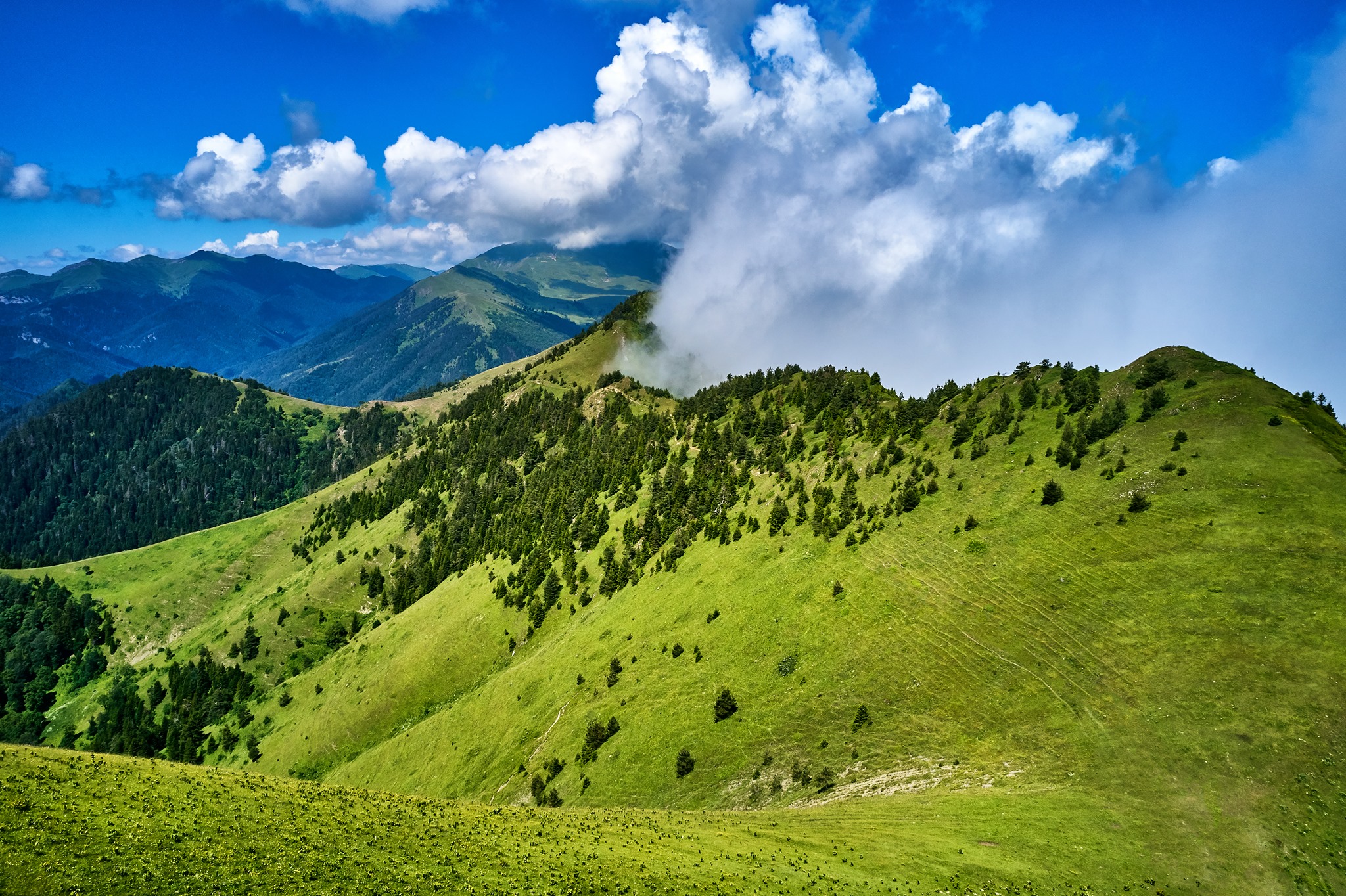
Welcome to Borjomi-Kharagauli National Park, one of the biggest and most beautiful national parks in all of Europe, not just Georgia! This park is in the middle of Georgia and covers a large area of the Lesser Caucasus mountains. It’s a great place for hikers and nature lovers. Picture huge, untouched forests covering mountains, high meadows full of colorful flowers in the summer, clean rivers flowing through deep valleys, and a chance to see a wide range of animals. This is what you can expect here.
[Image of a panoramic view from a hiking trail in Borjomi-Kharagauli National Park]
Borjomi-Kharagauli National Park was officially established in 1995 and opened to the public in 2001. Parts of it had been protected for a long time before that. It was created with help from other countries to protect this unique wilderness. Its main goals are to protect the forests and water sources, keep the variety of plants and animals alive, and let people enjoy and learn about nature through activities like hiking and horseback riding, all of which are done in a way that doesn’t hurt the environment.
It takes up a huge area of more than 85,000 hectares (850 square kilometers). As you go higher, the landscape changes a lot. At lower levels, there are dense forests of beech, oak, hornbeam, pine, fir, and spruce trees. Above the tree line, there are beautiful subalpine and alpine meadows. The highest point is more than 2,600 meters high! There are many different kinds of animals in the park because there are so many different kinds of habitats. You might see signs of Brown Bears, wolves, lynxes, Red Deer, Roe Deer, or Wild Boar. There are also birds like eagles and Caucasian Black Grouse that live here.
The well-developed network of hiking trails is what makes Borjomi-Kharagauli so great for visitors. There are 12 marked trails right now. Some are easy one-day walks that start near Borjomi or Kharagauli, and others are hard multi-day treks that go all the way across the park. Along these longer trails, there are basic tourist huts and campsites where hikers can spend the night. This lets you go deep into the wild for days at a time. At the park’s visitor centers in Borjomi and Kharagauli, you can get detailed maps and information, sign up for a hike, and even rent horses or guides.
[Image of a wooden tourist shelter in the park]
If you want to hike for a long time in Borjomi-Kharagauli National Park, you need to plan ahead. The weather in the mountains can change quickly, and the trails up high are covered in snow for most of the year, from November to May. But for those who are ready, the park has one of Europe’s largest protected mountain landscapes with wild nature, beautiful views, and quiet trails that will stay with you forever.
Basic ID
Official Name:
Borjomi-Kharagauli National Park (ბორჯომ-ხარაგაულის ეროვნული პარკი).
Type of Protected Area:
National Park (IUCN Category II). The goal is to protect large natural areas while still allowing for recreation, education, and scientific research that doesn’t harm the environment.
Date of Creation:
It was officially set up in 1995 and opened in 2001. It builds on older protected areas, like the Borjomi Reserve, which was built in the late 1800s.
Managing Body:
The Agency of Protected Areas (APA) of Georgia is in charge of the government.
Where it is and how to get there
Location:
Georgia. It covers three areas: Samtskhe-Javakheti, Imereti, and Shida Kartli. Includes parts of the municipalities of Borjomi, Kharagauli, Khashuri, Akhaltsikhe, and Baghdati. In the Lesser Caucasus mountains.
Map/Coordinates:
A big area, with 41°50′ N Latitude and 43°10′ E Longitude as its center. You can get detailed trail maps from visitor centers or the APA website.
Cities and towns nearby:
The main ways in are through the spa town of Borjomi (on the east side, near Likani) and the town of Kharagauli (on the west side). Atskuri, Marelisi, Nunisi, Zanavi, and Abastumani (near the southern edge) are other places you can get to or are close by.
How to Get There:
Getting to Borjomi is easy from Tbilisi. It’s about 160 km away and takes 2 to 2.5 hours by car, marshrutka (minibus), or train. The roads are paved. To get to Kharagauli, you can drive there or take the train from Tbilisi to Poti/Batumi. To Trailheads: Some trailheads near Borjomi/Kharagauli are easy to get to. You might need a car to get to more remote trailheads, like Marelisi and Atskuri. Depending on the road and weather, you might need a 4WD. Tbilisi (TBS) and Kutaisi (KUT) are the closest airports.
Size and how it looks
Size:
85,083 hectares (850.83 km²). One of the biggest national parks in Europe.
Topography:
The Lesser Caucasus range has a lot of mountains, with high ridges, steep slopes, deep river valleys, large forests, and meadows at high altitudes. The height of the mountains ranges from about 800 meters to 2,642 meters (Mount Sametskhvario).
Geology and Important Parts:
The Lesser Caucasus has folded mountain structures that make it stand out. The main things to see are the wide-open mountain and forest landscapes, not specific geological features like volcanoes or big caves.
Hydrology:
The park is home to a lot of rivers and streams that flow into bigger rivers like the Mtkvari (Kura) and the Rioni. There are many springs. At the highest elevations, you can find small alpine lakes. The well-known Borjomi mineral water springs are close to the park’s main wilderness area, but not in it.
Climate:
The weather changes a lot depending on the altitude. The weather is milder in lower valleys. High mountains have long, cold, snowy winters (usually from October to April, May, or June) and cool summers that could be rainy. The weather in the mountains can change very quickly. June through October is the best time to hike.
Importance and Purpose
Reason for designation:
to protect the large, diverse, and mostly undisturbed forest and mountain ecosystems in this part of the Lesser Caucasus; to protect its rich biodiversity, including large mammals; to provide opportunities for sustainable nature tourism, recreation, and education; and to protect important water sources.
Important Values:
It stands for a huge area of wilderness. A lot of Caucasian species that are only found in the region. A key corridor and habitat for big animals. Great possibilities for hiking, ecotourism, and learning about the environment. Safeguards important water and forest resources.
International Recognition:
- The first national park in the Caucasus that meets modern international standards was made possible by help from the German government (KfW) and WWF.
- Emerald Network Site that has been chosen.
- It used to be certified by the PAN Parks Foundation for its protection of wilderness and management of sustainable tourism.
Flora and fauna diversity
Ecosystems and habitats:
There are many different vertical zones, such as broadleaf deciduous forests (oak, hornbeam, beech), mixed forests, coniferous forests (pine, spruce, fir), subalpine forests (birch, maple, high-mountain oak), subalpine tall-herb meadows, and alpine meadows and carpets above the tree line.
Key Plant Species:
Oriental Spruce, Caucasian Fir, Scots Pine, Oriental Beech, various Oak species, Hornbeam, Maple, and Birch. A lot of plants grow in the forest understory. Rhododendrons, gentians, bellflowers, orchids, and many other colorful wildflowers grow in the subalpine and alpine zones. Many plants are only found in the Caucasus.
Important Animal Types:
Brown bear, wolf, Eurasian lynx, red deer (Cervus elaphus maral), roe deer, and wild boar are all mammals. There may be chamois (the number of them changes). Also, the Badger, Pine Marten, and Red Fox. Birds: High-altitude specialists like the Caucasian Black Grouse and the Caucasian Snowcock. Birds of prey like the Golden Eagle and the Griffon Vulture. Woodpeckers, owls, flycatchers, and tits are all birds that live in forests.
Endangered or Rare Species:
The Red Data Book of Georgia lists the Brown Bear, Lynx, and Red Deer as endangered or rare species. Some birds, like the Golden Eagle, are protected. The Caucasian Salamander may inhabit appropriate environments.
Information for Visitors
Visitor Center(s):
Yes, there are two main centers: The Borjomi Visitor Center is in Likani, which is just outside of Borjomi town. The Kharagauli Visitor Center is in the town of Kharagauli. At the Atskuri and Marelisi entrances, there are smaller ranger stations and visitor shelters. Services: Maps, detailed trail information, registration for hikes and shelters, booking of shelters and campsites, renting guides and horses, basic exhibits, and souvenirs. There are contact details on the APA website.
Hours of Operation and Seasons:
Most of the time, visitor centers are open during regular business hours (check the APA website). Technically, park trails are always open, but high-altitude trails (most multi-day routes) are closed because of snow from late October/November to late May/June. June to mid-October is the best time to go hiking. You can hike on lower elevation trails for longer.
Fees and Permits:
Yes, there are entrance fees for each person per day. There are different costs for renting horses, hiring guides, or using tourist shelters or designated campsites. Before you can start a multi-day hike or stay in a shelter or campsite, you usually have to register and pay at a visitor center. Visit the APA website to find out what the current fees are.
Paths and Routes:
There are 12 marked trails that make up a large network. They are good for people of all fitness levels and timeframes: Short or day hikes include the Footprint Trail (near Likani), the Information Trail (near Kharagauli), and the Panorama Trail (a one-day loop near Likani). Multi-day hikes include the St. Andrew’s Trail (4 days, hard, goes through the park), the Nikoloz Romanov Trail (2 days), and trails that connect different entrances, like Marelisi-Likani or Atskuri-Likani. Some trails are easy, while others are hard. There are a number of paths where you can ride a horse.
Activities:
The main activity is hiking or trekking. Camping (only in certain areas), horseback riding, snowshoeing (in the winter, on a few lower trails), birdwatching, nature photography, and educational tours.
Where to stay:
Inside the park, there are basic tourist shelters (wooden huts with bunk beds, a table, and a wood stove) and designated campsites (flat areas that are marked and often near a water source or shelter). It is very important to book ahead through the visitor center. Nearby: There are many hotels, guesthouses, and homestays in Borjomi town, Kharagauli town, and villages near other park entrances.
Facilities:
Visitor centers, marked trails, tourist shelters, designated campsites, picnic areas near some entrances, and information boards are all available. There are toilets at visitor centers and shelters, but they are usually pit toilets. Most trails have reliable water sources, like springs and streams, but it’s best to treat the water (filter it or boil it) before drinking it.
Advice on safety:
Getting ready is important: This is a big, wild mountain area. Check the weather reports; things can change quickly. Bring the right clothes, including warm layers and rain gear even in the summer, sturdy hiking boots, navigation tools (a map, compass, and GPS are all good), a first-aid kit, sunscreen, and a headlamp. Food and Water: Bring enough food for your trip. There are places to get water, but you should bring ways to clean it. Registration: Always let a visitor center know your plans and route, especially if you are going on a hike that lasts more than one day. Wildlife: Be careful of bears and other animals. Talk, sing, or carry a bell while hiking to keep bears from sneaking up on you. Keep food safe at night. Do not give animals food. Fitness and Experience: Pick trails that are right for your level of fitness. You need to get used to high-altitude trails. If you’re new to hiking or trying a difficult route, you might want to hire a registered guide. When there is an emergency, have a charged phone with you, but be ready for weak signals in remote areas. In Georgia, the emergency number is 112. Tell someone about your plans.
Rules and Laws
Code of Conduct:
Follow the Leave No Trace rules exactly: pack out everything you pack in, stay on marked trails, camp only at designated sites, use shelters respectfully, and leave as little impact as possible.
Prohibitions:
No hunting is allowed. Check the rules for fishing (they probably don’t allow it). At official campsites and shelters, you can usually only make fires in designated fire pits (check for seasonal fire bans). Don’t cut down trees or gather rocks or plants. You can’t feed wild animals. You usually need special permission to use drones. Make sure your pets are under control (look up the rules for trails and shelters).
Zoning:
The park has different management goals for each zone, but visitors mainly use the marked trail network and designated overnight spots in recreational or wilderness zones.
Protecting and Managing
Managing Body:
The Borjomi-Kharagauli National Park Administration runs the park. It is part of the Agency of Protected Areas (APA). Rangers keep an eye on the wildlife, help visitors, and patrol the park.
Conservation Efforts:
Conservation efforts include monitoring biodiversity (especially large mammals), patrolling to stop poaching, preventing and responding to forest fires, keeping trails and shelters in good shape, managing the effects of visitors, promoting environmental education, and supporting scientific research.
Threats and Problems:
Forest fires are still a big problem (there were big fires near Borjomi in 2008 and 2017). Illegal logging and poaching, especially near the edges of parks. Sustainably managing the growing pressure from tourists. Effects of climate change on ecosystems. Possible stress on the park from nearby infrastructure projects.
Culture and History
A short history:
People have lived in this area for a long time, and it used to be royal hunting grounds. The Borjomi Reserve was the first place to get formal protection in the 1880s. This was because the Russian imperial family was interested in Borjomi mineral water. After Georgia became independent, the idea for the modern National Park came about. It was built with a lot of help from other countries (WWF, Germany) and opened to the public in 2001.
Cultural Importance:
The park’s core is made up of natural wilderness, but the area around it has a lot of history. There are medieval fortresses (like Atskuri and the Golden Fortress), churches, and monasteries close to the park’s edges. The town of Borjomi is a historic spa resort with buildings that are one of a kind. People in local villages still live the way they always have.
Unique Traits and Fun Facts
- It protects a huge area of Lesser Caucasus wilderness and is one of the biggest national parks in Europe.
- There are a lot of marked hiking trails with overnight shelters, so you can go on multi-day wilderness treks.
- It was the first national park in the Caucasus region that was built to modern international standards.
- Springs near the park area are where the world-famous Borjomi mineral water comes from.
- Gives you the chance to see different ecosystems, from forests to alpine meadows, all in one protected area.
Leave a review